Listening to Lakes: Using Seismic Noise to Monitor Ice Cover and Earth Structure


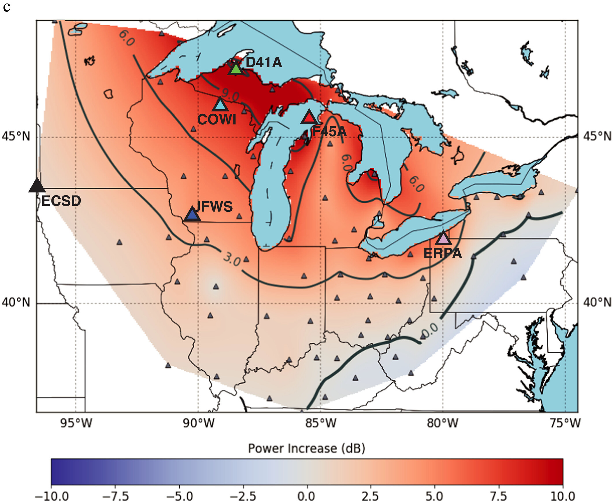
Comparing normal and frozen noise conditions from Great Lakes. (Fig. 1: Anthony et al., 2018, GRL)

Lakes are Surprisingly Noisy

When we think of earthquakes, we imagine faults rupturing deep beneath Earth’s surface. Yet many of the vibrations recorded by seismometers are generated by something much closer to the surface—waves crashing into one another and along the shorelines of oceans and large lakes.

As wind-driven waves interact, they transmit energy into the solid Earth as tiny vibrations called microseisms that continually shake the ground. Although too small to be felt by people, these signals can travel hundreds of kilometers and are recorded as a constant hum at seismic stations.

Rather than treating this background “noise” as an inconvenience, seismologists increasingly use it as a valuable source of information about both Earth’s interior and the surface processes that generate it.

The Great Lakes of North America provide an ideal natural laboratory for studying these signals as they undergo dramatic seasonal changes. Every winter, large portions of the lakes freeze, fundamentally altering how wind, waves, and ice interact with the solid Earth.

What Happens When a Lake Freezes?
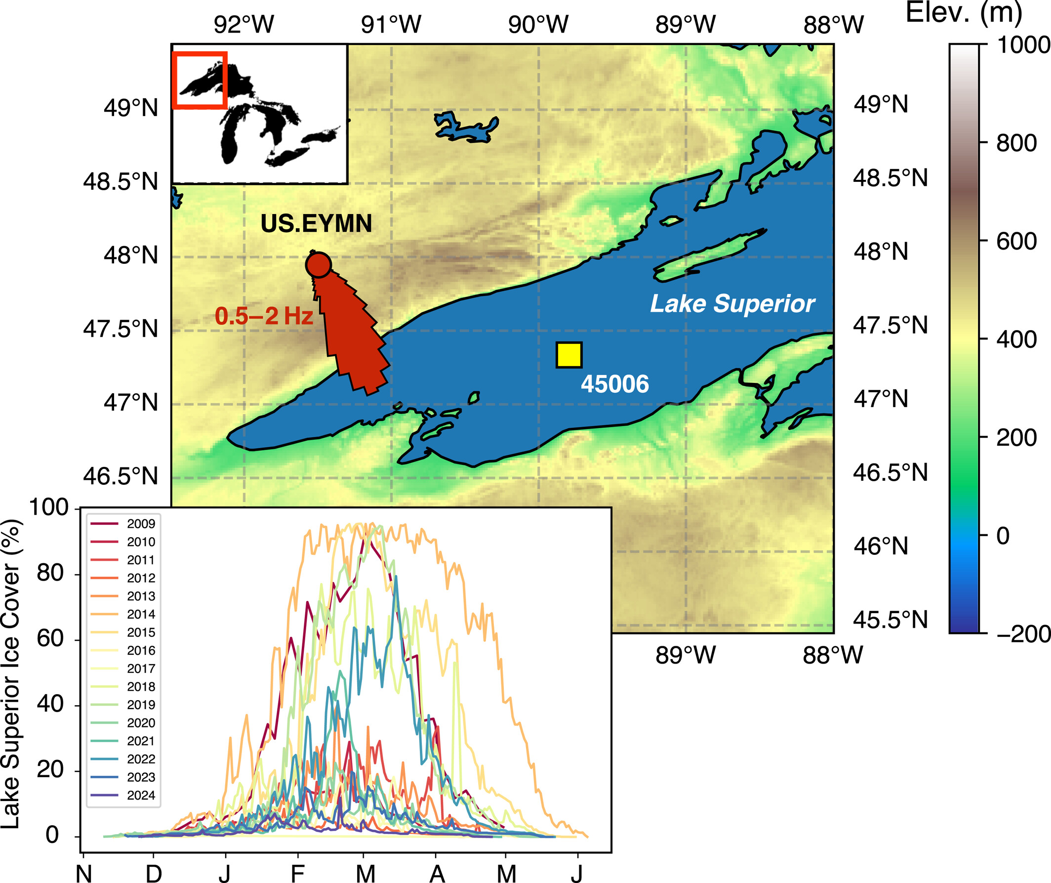
Seismic station EYMN detecting microseism from Lake Superior, with ice cover from 2009-2024. (Fig. 1: Russell & Carchedi, 2026, GRL) Microseisms ultimately derive their energy from waves moving across open water. As ice forms, it reduces the surface area available for wind to generate wave systems, altering the strength and distribution of seismic energy transmitted into the surrounding crust.

This suggests an intriguing possibility: could we estimate nearby lake ice cover simply by listening to variations in lake microseism strength?

To answer this question, we compared continuous seismic observations with satellite-derived ice cover and buoy measurements of wind and wave conditions spanning multiple winters across the Great Lakes.
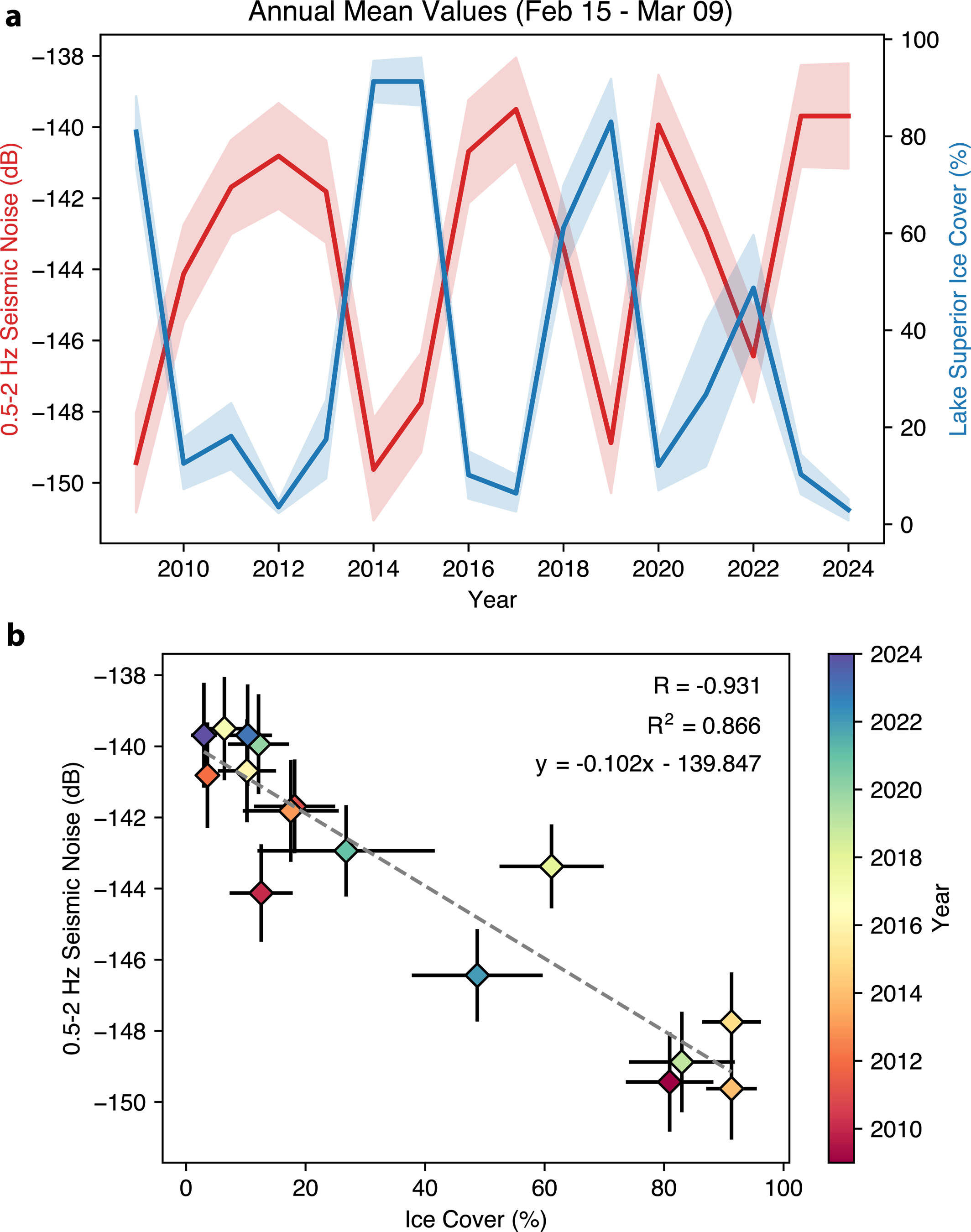
Correlation between lake microseism noise at EYMN and ice cover on Lake Superior (Fig. 3: Russell & Carchedi, 2026, GRL).

Seismic Noise as a Climate Proxy

Our results demonstrate a markedly strong relationship between seasonal ice cover and seismic noise generated by the Great Lakes. As ice coverage increases, microseism amplitudes decrease. When the lakes thaw each spring, seismic energy levels return.

Because seismic stations operate continuously and in nearly all weather conditions, they offer an independent way to monitor lake ice coverage through time. Unlike optical satellite observations, seismic measurements are unaffected by cloud cover or polar darkness and thus provide a continuous record of environmental change.

These findings demonstrate that seismic observations can provide valuable information not only about Earth’s interior, but also about interactions between atmosphere, hydrosphere, cryosphere, and the solid Earth.

Where Does Lake Noise Come From?

Although we know that lake ice strongly influences microseism generation, many fundamental questions remain unanswered.

Exactly where within the lakes are these signals primarily generated? How do changing wind conditions, wave height, water depth, and geometry along shoreline and lake bottom control their strength?

Answering these questions requires moving beyond observations make from land.

One exciting next step is to deploy seismometers directly on the lake floor alongside colocated wave buoys, meteorological stations, and other environmental sensors. By simultaneously measuring seismic vibrations, wind, wave, and ice conditions, we can directly observe the physical processes responsible for generating lake microseisms.
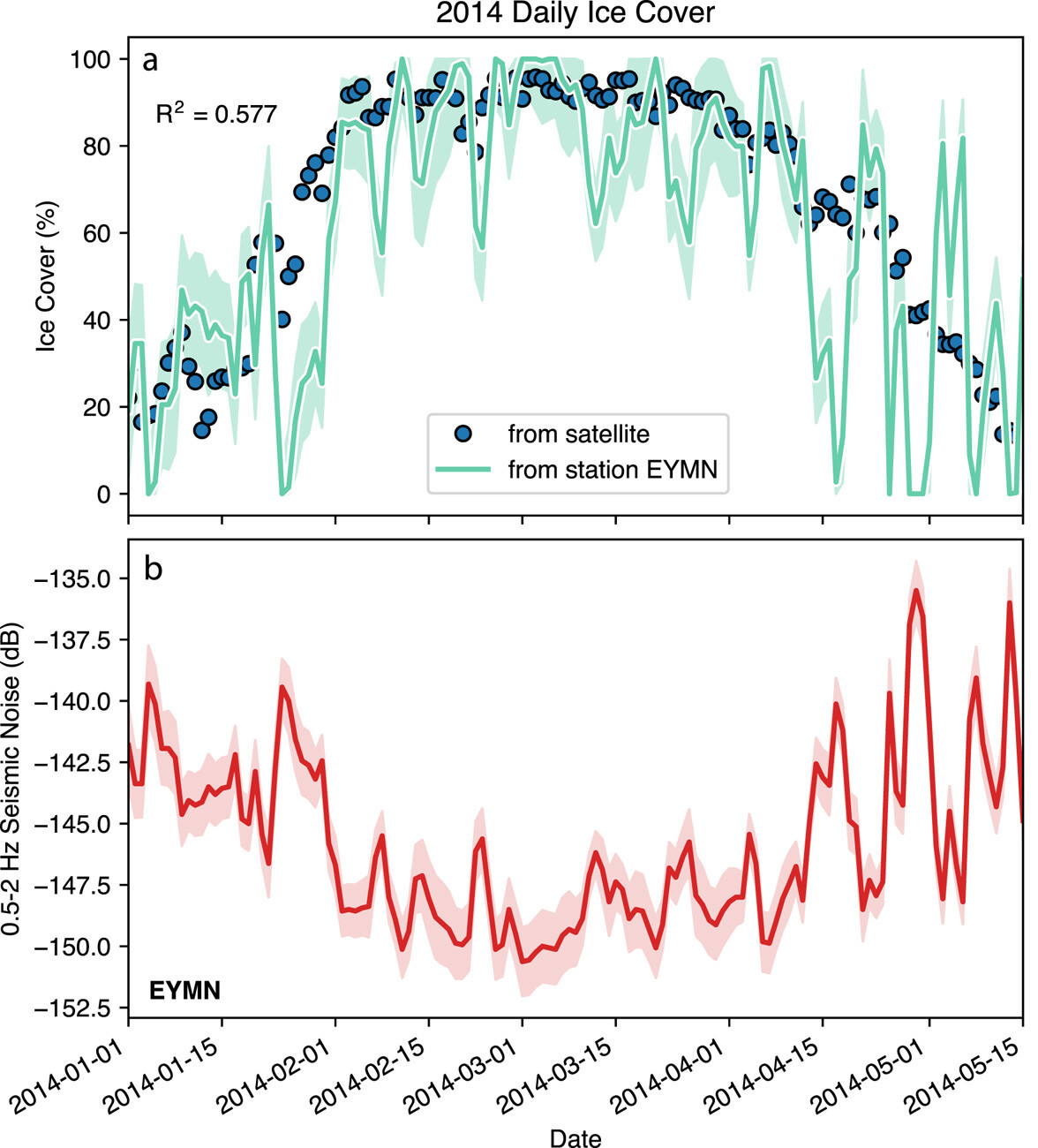
Application of linear model to estimate daily ice cover from seismic noise observations in 2014 (Fig. 4: Russell & Carchedi, 2026, GRL).

From Environmental Noise to Earth Imaging

Understanding how lake microseisms are generated has benefits extending beyond environmental monitoring. Because these signals are present near continuously, they may provide an untapped energy source for ambient-noise seismic imaging, a technique that reconstructs Earth’s shallow structure using naturally occurring vibrations rather than earthquakes or active seismic sources.

If lake-generated microseisms prove sufficiently energetic and stable, they could enable high-resolution imaging of sedimentary basins, glacial deposits, faults, and groundwater systems surrounding the Great Lakes. Improved images of shallow Earth structure are particularly valuable because sedimentary basins can strongly amplify earthquake shaking, making them important contributors to seismic hazard in many populated regions.

Unlike traditional active-source surveys, which often require explosives or disruptive vibrating trucks to generate seismic waves, ambient-noise methods rely entirely on naturally occurring signals. This makes passive imaging more environmentally friendly, well suited for repeated measurements through time, and practical in locations where active surveys may be prohibitively expensive or disruptive.

Developing this capability requires understanding not only the Earth’s response to ambient seismic waves, but also the physical mechanisms for generating the waves themselves.

Looking Forward

Our work demonstrates that seismic observations can track and predict seasonal changes in Great Lakes ice cover, emphasizing the close connection between environmental conditions on the surface and ambient seismic noise within the solid Earth.

The next frontier is understanding the physics of microseism generation with the help of observations much closer to the source. Unlike ocean-bottom seismometers deployed along continental margins, which are frequently damaged or lost to commercial fishing trawlers, lake-bottom deployments offer a comparatively protected and more accessible environment for long-duration experiments. The Great Lakes therefore provide an exceptional site for studying microseism source physics with unprecedented detail.

Sometimes the most useful seismic source isn’t an earthquake beneath your feet—it may simply be a windy day on the water.

Updated August 2026.

Check out our paper to learn more!

Russell, JB. and CJW. Carchedi (2026). Estimating ice cover on the Great Lakes using seismic ambient noise Geophysical Research Letters, 53 (5), e2025GL120498. https://doi.org/10.1029/2025GL120498